
I do not happen to have that picture, so 1000 words it is...(don't count)!
Good morning! This is the first day of Vortex2 operations. We lost 2 of the mobile mesonet vehicles to a muddy road...if anyone is just south of the Nebraska border, the mesonets might appreciate pizza (2 pepperoni, 1 mushroom, and 1 cheese will do)...and a tow.
Let's start from the beginning...
In order to forecast the weather, meteorologists use models--not the kind that you draw in art class (after you have mastered the fruit platter)--but the kind that combine physics (how things work) and mathematics (solving for how things work). Meteorologists spend a lot of time looking at models prior to a mission. Meteorologists also look to see if a model is verifying... In other words if a model predicted it was suppose to be 75 degrees by 200 p.m. in Wichita--is it? If it isn't, why isn't it? We adjust our forecasts are based on the evolving weather scenario...
Today unfolded as follows:
Phase 1: Status Quo
630: Woke up.
730: Rolled out of bed.
830: Dragged a comb across my head (showered and dressed first).
945: Attended the weather briefing. The models indicated there were 2 regions in Kansas that had environments which "might" be favor supercells (but probably not tornadoes) later today (meteorologists really are lawyers at heart): northwest Kansas, which was pretty close to our current location, and southeast Kansas, which was about 5 hours away. Eeeny, meeny, miney, moe...
Phase 2: Watch and Wait (and Work!)
1100: Parking lot.
1200: Parking lot. Based on evolving weather, the decision was made to target NW Kansas.
100: Parking lot. Applied sunblock.
200: Parking lot.
300: Parking lot. Applied sunblock.
400: Parking lot.
Phase 3: Intercept
500: Drive west. NOW.
600: This storm has potential! Deploy!
700: What storm?
730: New storm! Let's move north! This storm looks good...!
830: What storm?
900: Fuel stop.
Phase 4: Food
1100: Dinner.
In summary, today was a great practice day for Vortex2! We realized early on that the storms would not be tornadic, so we practiced setting up the radars, tornado pods, disdrometers, mobile mesontes, etc. We gathered data to make sure it looked reasonable (some teams learned that it was necessary to turn on their instruments in order to get data...good to know, right?). So now we are ready...
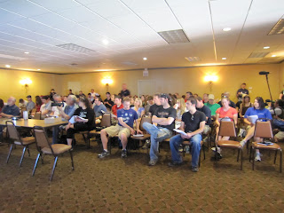
Picture 1 (Left): A gathering of the masses...The Vortex2 public weather briefing.
Picture 2 (Right): The famed parking lot.


"A Day in the Life", eh? Good choice.
ReplyDeleteSimilar startup for us, however we selected region 2 and had an hour more "parking lot"... Decided to go NW, then but turned back E after a while to watch the storm at Salina - about half an hour too late to get a good view. Now, more luck next time...
ReplyDeleteThere's always HOPE in KS....
ReplyDeletehttp://www.crh.noaa.gov/news/display_cmsstory.php?wfo=top&storyid=52005&source=0
Two swaths of strong winds and large hail were caused by the storms Thursday night. A southern swath of severe weather was caused by a supercell which moved through Dickinson, Morris, Lyon, and Osage counties. Hail up to the size of baseballs was reported as well as strong winds up to 90 to 100 mph. A house and its attached garage near Hope, KS were seriously damaged as a result of the strong winds just south of the supercell. Other outbuildings were also destroyed near Hope.
Shoulda gone 90 mi East of Hays!!! Bummer. CW2795
Heard about the sucess from the weather channel! Yay! Still have a week left, though.
ReplyDeletehot girl | hot girl | cute girl | girl xinh | funny |
ReplyDeletetravel vietnam | visit vietnam | funny picture | funny picture
socks proxy | socks5 | proxy | proxy free
People like the picture a lot my brother runs a logo design agency in Karachi. He used to do photo shoots and took really good pictures. He used to do the same photo shoots for everyone at family functions. A man asked him if he wanted something nice written on my picture in 100 words, so he gave it to him using words.
ReplyDelete